|
|
|||||||||||||||||
| Point ID: 5492 | Downloads | Plots | Site Data | Code: 05MA019 |
|
|
|||||||||||||||||
| Download | |
|---|---|
| Site Descriptor Information | Site Time Series Data |
| Link to all available data | |
| View: | Time Series | All |
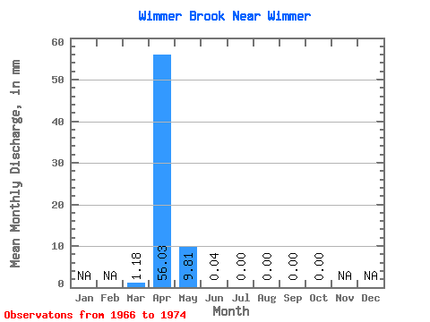
| Units: | m3/s |
| Statistic | Jan | Feb | Mar | Apr | May | Jun | Jul | Aug | Sep | Oct | Nov | Dec | Annual |
|---|---|---|---|---|---|---|---|---|---|---|---|---|---|
| Mean | 0.53 | 25.06 | 4.38 | 0.01 | 0.00 | 0.00 | 0.00 | 0.00 | |||||
| Standard Deviation | 1.09 | 21.85 | 4.50 | 0.02 | 0.00 | 0.00 | 0.00 | 0.00 | |||||
| Min | 0.00 | 0.12 | 0.00 | 0.00 | 0.00 | 0.00 | 0.00 | 0.00 | |||||
| Max | 2.91 | 70.60 | 11.05 | 0.07 | 0.00 | 0.00 | 0.00 | 0.00 | |||||
| Coefficient of Variation | 2.06 | 0.87 | 1.03 | 1.85 |
 Return to R-Arctic Net Home Page