|
|
|||||||||||||||||
| Point ID: 549 | Downloads | Plots | Site Data | Code: 05FC006 |
|
|
|||||||||||||||||
| Download | |
|---|---|
| Site Descriptor Information | Site Time Series Data |
| Link to all available data | |
| View: | Time Series | All |
| Units: | m3/s |
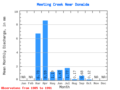
| Statistic | Jan | Feb | Mar | Apr | May | Jun | Jul | Aug | Sep | Oct | Nov | Dec | Annual |
|---|---|---|---|---|---|---|---|---|---|---|---|---|---|
| Mean | 2.89 | 3.69 | 0.51 | 0.63 | 0.76 | 0.07 | 0.29 | 0.05 | |||||
| Standard Deviation | 3.93 | 3.19 | 1.01 | 1.27 | 0.94 | 0.08 | 0.56 | 0.13 | |||||
| Min | 0.01 | 0.65 | 0.03 | 0.00 | 0.09 | 0.00 | 0.00 | 0.00 | |||||
| Max | 9.19 | 8.79 | 2.31 | 2.89 | 2.17 | 0.18 | 1.30 | 0.31 | |||||
| Coefficient of Variation | 1.36 | 0.86 | 1.96 | 2.00 | 1.24 | 1.05 | 1.93 | 2.40 |
 Return to R-Arctic Net Home Page