|
|
|||||||||||||||||
| Point ID: 5474 | Downloads | Plots | Site Data | Code: 05LB008 |
|
|
|||||||||||||||||
| Download | |
|---|---|
| Site Descriptor Information | Site Time Series Data |
| Link to all available data | |
| View: | Time Series | All |
| Units: | m3/s |
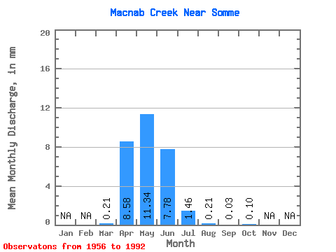
| Statistic | Jan | Feb | Mar | Apr | May | Jun | Jul | Aug | Sep | Oct | Nov | Dec | Annual |
|---|---|---|---|---|---|---|---|---|---|---|---|---|---|
| Mean | 0.17 | 7.56 | 9.97 | 6.85 | 1.28 | 0.18 | 0.02 | 0.09 | |||||
| Standard Deviation | 0.41 | 8.68 | 12.81 | 15.10 | 3.35 | 0.46 | 0.07 | 0.34 | |||||
| Min | 0.00 | 0.00 | 0.00 | 0.00 | 0.00 | 0.00 | 0.00 | 0.00 | |||||
| Max | 1.47 | 34.95 | 45.60 | 63.98 | 13.16 | 1.90 | 0.33 | 1.53 | |||||
| Coefficient of Variation | 2.44 | 1.15 | 1.28 | 2.20 | 2.61 | 2.49 | 3.78 | 3.75 |
 Return to R-Arctic Net Home Page