|
|
|||||||||||||||||
| Point ID: 5471 | Downloads | Plots | Site Data | Code: 05LB005 |
|
|
|||||||||||||||||
| Download | |
|---|---|
| Site Descriptor Information | Site Time Series Data |
| Link to all available data | |
| View: | Time Series | All |
| Units: | m3/s |
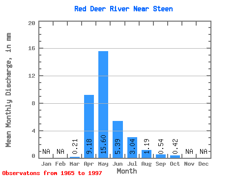
| Statistic | Jan | Feb | Mar | Apr | May | Jun | Jul | Aug | Sep | Oct | Nov | Dec | Annual |
|---|---|---|---|---|---|---|---|---|---|---|---|---|---|
| Mean | 0.12 | 5.56 | 9.44 | 3.27 | 1.84 | 0.72 | 0.33 | 0.25 | |||||
| Standard Deviation | 0.12 | 4.55 | 10.70 | 3.55 | 2.38 | 1.02 | 0.52 | 0.28 | |||||
| Min | 0.00 | 0.10 | 0.08 | 0.03 | 0.02 | 0.00 | 0.00 | 0.00 | |||||
| Max | 0.48 | 15.62 | 35.31 | 15.48 | 11.21 | 3.97 | 2.05 | 1.06 | |||||
| Coefficient of Variation | 0.95 | 0.82 | 1.13 | 1.09 | 1.29 | 1.41 | 1.57 | 1.12 |
 Return to R-Arctic Net Home Page