|
|
|||||||||||||||||
| Point ID: 5465 | Downloads | Plots | Site Data | Code: 05LA005 |
|
|
|||||||||||||||||
| Download | |
|---|---|
| Site Descriptor Information | Site Time Series Data |
| Link to all available data | |
| View: | Time Series | All |
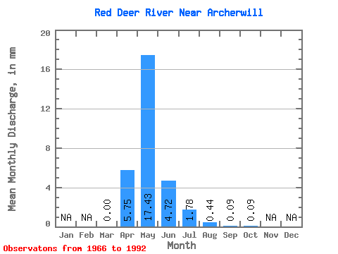
| Units: | m3/s |
| Statistic | Jan | Feb | Mar | Apr | May | Jun | Jul | Aug | Sep | Oct | Nov | Dec | Annual |
|---|---|---|---|---|---|---|---|---|---|---|---|---|---|
| Mean | 0.00 | 3.47 | 10.53 | 2.85 | 1.07 | 0.26 | 0.05 | 0.05 | |||||
| Standard Deviation | 0.01 | 3.73 | 14.61 | 4.14 | 1.26 | 0.38 | 0.10 | 0.09 | |||||
| Min | 0.00 | 0.00 | 0.01 | 0.01 | 0.00 | 0.00 | 0.00 | 0.00 | |||||
| Max | 0.02 | 13.65 | 43.53 | 16.77 | 3.75 | 1.48 | 0.34 | 0.36 | |||||
| Coefficient of Variation | 3.09 | 1.07 | 1.39 | 1.45 | 1.18 | 1.44 | 1.94 | 1.79 |
 Return to R-Arctic Net Home Page