|
|
|||||||||||||||||
| Point ID: 5450 | Downloads | Plots | Site Data | Code: 05KF001 |
|
|
|||||||||||||||||
| Download | |
|---|---|
| Site Descriptor Information | Site Time Series Data |
| Link to all available data | |
| View: | Time Series | All |
| Units: | m3/s |
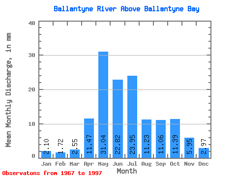
| Statistic | Jan | Feb | Mar | Apr | May | Jun | Jul | Aug | Sep | Oct | Nov | Dec | Annual |
|---|---|---|---|---|---|---|---|---|---|---|---|---|---|
| Mean | 2.10 | 1.73 | 2.55 | 11.47 | 31.04 | 22.82 | 23.95 | 11.23 | 11.06 | 11.39 | 5.95 | 2.98 | 138.49 |
| Standard Deviation | 1.02 | 0.99 | 1.70 | 7.50 | 15.33 | 14.56 | 34.89 | 7.70 | 7.85 | 5.74 | 3.34 | 1.62 | 69.60 |
| Min | 0.35 | 0.20 | 0.28 | 1.77 | 6.60 | 3.71 | 3.65 | 2.13 | 1.94 | 2.98 | 1.17 | 0.54 | 58.55 |
| Max | 4.42 | 3.72 | 8.13 | 31.88 | 69.31 | 75.13 | 191.90 | 28.21 | 31.46 | 23.49 | 13.82 | 7.58 | 375.60 |
| Coefficient of Variation | 0.49 | 0.57 | 0.67 | 0.65 | 0.49 | 0.64 | 1.46 | 0.69 | 0.71 | 0.50 | 0.56 | 0.54 | 0.50 |
 Return to R-Arctic Net Home Page