|
|
|||||||||||||||||
| Point ID: 545 | Downloads | Plots | Site Data | Code: 05FC002 |
|
|
|||||||||||||||||
| Download | |
|---|---|
| Site Descriptor Information | Site Time Series Data |
| Link to all available data | |
| View: | Time Series | All |
| Units: | m3/s |
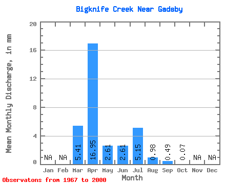
| Statistic | Jan | Feb | Mar | Apr | May | Jun | Jul | Aug | Sep | Oct | Nov | Dec | Annual |
|---|---|---|---|---|---|---|---|---|---|---|---|---|---|
| Mean | 3.83 | 12.01 | 1.85 | 1.84 | 3.66 | 0.70 | 0.34 | 0.04 | |||||
| Standard Deviation | 6.43 | 17.52 | 5.33 | 4.51 | 6.84 | 2.06 | 1.83 | 0.17 | |||||
| Min | 0.00 | 0.00 | 0.00 | 0.00 | 0.00 | 0.00 | 0.00 | 0.00 | |||||
| Max | 25.58 | 83.34 | 26.18 | 21.97 | 27.38 | 9.62 | 10.67 | 0.91 | |||||
| Coefficient of Variation | 1.68 | 1.46 | 2.87 | 2.45 | 1.87 | 2.94 | 5.32 | 3.83 |
 Return to R-Arctic Net Home Page