|
|
|||||||||||||||||
| Point ID: 5446 | Downloads | Plots | Site Data | Code: 05KE005 |
|
|
|||||||||||||||||
| Download | |
|---|---|
| Site Descriptor Information | Site Time Series Data |
| Link to all available data | |
| View: | Time Series | All |
| Units: | m3/s |
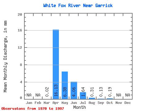
| Statistic | Jan | Feb | Mar | Apr | May | Jun | Jul | Aug | Sep | Oct | Nov | Dec | Annual |
|---|---|---|---|---|---|---|---|---|---|---|---|---|---|
| Mean | 0.02 | 15.10 | 5.97 | 3.80 | 1.54 | 0.29 | 0.12 | 0.18 | |||||
| Standard Deviation | 0.02 | 17.39 | 8.25 | 7.55 | 3.36 | 0.53 | 0.36 | 0.38 | |||||
| Min | 0.00 | 0.00 | 0.00 | 0.00 | 0.00 | 0.00 | 0.00 | 0.00 | |||||
| Max | 0.09 | 68.20 | 29.93 | 36.45 | 16.90 | 2.19 | 1.90 | 1.83 | |||||
| Coefficient of Variation | 1.45 | 1.15 | 1.38 | 1.99 | 2.19 | 1.84 | 3.01 | 2.10 |
 Return to R-Arctic Net Home Page