|
|
|||||||||||||||||
| Point ID: 5444 | Downloads | Plots | Site Data | Code: 05KE002 |
|
|
|||||||||||||||||
| Download | |
|---|---|
| Site Descriptor Information | Site Time Series Data |
| Link to all available data | |
| View: | Time Series | All |
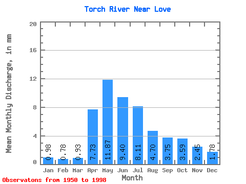
| Units: | m3/s |
| Statistic | Jan | Feb | Mar | Apr | May | Jun | Jul | Aug | Sep | Oct | Nov | Dec | Annual |
|---|---|---|---|---|---|---|---|---|---|---|---|---|---|
| Mean | 0.98 | 0.78 | 0.93 | 7.73 | 11.87 | 9.40 | 8.11 | 4.70 | 3.75 | 3.58 | 2.45 | 1.78 | 56.43 |
| Standard Deviation | 1.09 | 0.76 | 0.70 | 6.61 | 9.89 | 9.22 | 7.45 | 5.64 | 5.47 | 3.34 | 2.75 | 2.80 | 41.75 |
| Min | 0.22 | 0.19 | 0.00 | 1.42 | 1.65 | 0.79 | 0.33 | 0.34 | 0.28 | 0.65 | 0.56 | 0.32 | 12.70 |
| Max | 4.47 | 3.20 | 3.14 | 30.82 | 45.44 | 49.72 | 35.36 | 35.19 | 36.01 | 18.72 | 13.21 | 12.04 | 168.30 |
| Coefficient of Variation | 1.11 | 0.97 | 0.75 | 0.85 | 0.83 | 0.98 | 0.92 | 1.20 | 1.46 | 0.93 | 1.12 | 1.57 | 0.74 |
 Return to R-Arctic Net Home Page