|
|
|||||||||||||||||
| Point ID: 5432 | Downloads | Plots | Site Data | Code: 05KB009 |
|
|
|||||||||||||||||
| Download | |
|---|---|
| Site Descriptor Information | Site Time Series Data |
| Link to all available data | |
| View: | Time Series | All |
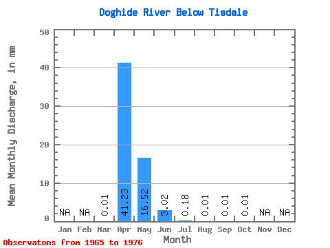
| Units: | m3/s |
| Statistic | Jan | Feb | Mar | Apr | May | Jun | Jul | Aug | Sep | Oct | Nov | Dec | Annual |
|---|---|---|---|---|---|---|---|---|---|---|---|---|---|
| Mean | 0.02 | 40.81 | 16.35 | 3.00 | 0.18 | 0.00 | 0.00 | 0.01 | |||||
| Standard Deviation | 0.03 | 26.96 | 15.87 | 0.16 | 0.13 | 0.01 | 0.01 | 0.01 | |||||
| Min | 0.00 | 0.66 | 0.68 | 2.88 | 0.09 | 0.00 | 0.00 | 0.01 | |||||
| Max | 0.05 | 69.38 | 44.90 | 3.11 | 0.28 | 0.01 | 0.01 | 0.01 | |||||
| Coefficient of Variation | 1.73 | 0.66 | 0.97 | 0.05 | 0.73 | 1.41 | 1.41 | 0.47 |
 Return to R-Arctic Net Home Page