|
|
|||||||||||||||||
| Point ID: 5418 | Downloads | Plots | Site Data | Code: 05KA003 |
|
|
|||||||||||||||||
| Download | |
|---|---|
| Site Descriptor Information | Site Time Series Data |
| Link to all available data | |
| View: | Time Series | All |
| Units: | m3/s |
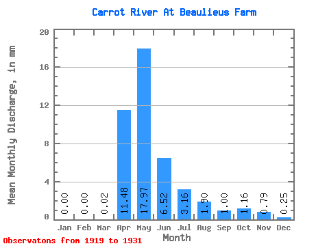
| Statistic | Jan | Feb | Mar | Apr | May | Jun | Jul | Aug | Sep | Oct | Nov | Dec | Annual |
|---|---|---|---|---|---|---|---|---|---|---|---|---|---|
| Mean | 0.00 | 0.00 | 0.00 | 2.90 | 4.54 | 1.65 | 0.80 | 0.48 | 0.25 | 0.29 | 0.20 | 0.06 | 25.55 |
| Standard Deviation | 0.00 | 0.00 | 0.01 | 3.53 | 5.24 | 1.11 | 0.59 | 0.64 | 0.34 | 0.42 | 0.27 | 0.09 | 10.92 |
| Min | 0.00 | 0.00 | 0.00 | 0.20 | 0.29 | 0.16 | 0.13 | 0.00 | 0.00 | 0.00 | 0.00 | 0.00 | 18.43 |
| Max | 0.00 | 0.00 | 0.03 | 12.44 | 15.40 | 3.94 | 1.89 | 1.92 | 0.90 | 1.29 | 0.57 | 0.19 | 38.12 |
| Coefficient of Variation | 2.83 | 1.22 | 1.15 | 0.67 | 0.73 | 1.33 | 1.34 | 1.44 | 1.34 | 1.47 | 0.43 |
 Return to R-Arctic Net Home Page