|
|
|||||||||||||||||
| Point ID: 541 | Downloads | Plots | Site Data | Code: 05FA912 |
|
|
|||||||||||||||||
| Download | |
|---|---|
| Site Descriptor Information | Site Time Series Data |
| Link to all available data | |
| View: | Time Series | All |
| Units: | m3/s |
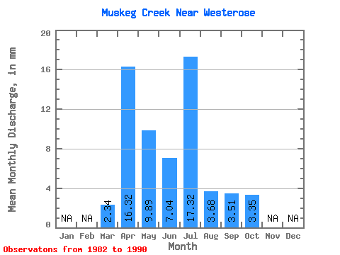
| Statistic | Jan | Feb | Mar | Apr | May | Jun | Jul | Aug | Sep | Oct | Nov | Dec | Annual |
|---|---|---|---|---|---|---|---|---|---|---|---|---|---|
| Mean | 2.25 | 15.67 | 9.48 | 6.76 | 16.61 | 3.52 | 3.37 | 3.21 | |||||
| Standard Deviation | 12.20 | 7.81 | 8.41 | 21.13 | 2.61 | 1.60 | 1.78 | ||||||
| Min | 2.25 | 4.47 | 2.45 | 1.84 | 0.94 | 0.91 | 1.56 | 1.64 | |||||
| Max | 2.25 | 38.73 | 26.46 | 25.07 | 48.48 | 7.65 | 6.90 | 7.39 | |||||
| Coefficient of Variation | 0.78 | 0.82 | 1.25 | 1.27 | 0.74 | 0.47 | 0.56 |
 Return to R-Arctic Net Home Page