|
|
|||||||||||||||||
| Point ID: 5396 | Downloads | Plots | Site Data | Code: 05JJ009 |
|
|
|||||||||||||||||
| Download | |
|---|---|
| Site Descriptor Information | Site Time Series Data |
| Link to all available data | |
| View: | Time Series | All |
| Units: | m3/s |
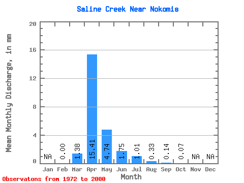
| Statistic | Jan | Feb | Mar | Apr | May | Jun | Jul | Aug | Sep | Oct | Nov | Dec | Annual |
|---|---|---|---|---|---|---|---|---|---|---|---|---|---|
| Mean | 0.00 | 0.11 | 1.20 | 0.37 | 0.14 | 0.08 | 0.03 | 0.01 | 0.01 | ||||
| Standard Deviation | 0.24 | 1.81 | 0.57 | 0.21 | 0.17 | 0.07 | 0.04 | 0.02 | |||||
| Min | 0.00 | 0.00 | 0.00 | 0.00 | 0.00 | 0.00 | 0.00 | 0.00 | 0.00 | ||||
| Max | 0.00 | 0.91 | 7.86 | 2.85 | 0.87 | 0.78 | 0.27 | 0.20 | 0.10 | ||||
| Coefficient of Variation | 2.24 | 1.51 | 1.54 | 1.55 | 2.17 | 2.77 | 3.49 | 2.85 |
 Return to R-Arctic Net Home Page