|
|
|||||||||||||||||
| Point ID: 5391 | Downloads | Plots | Site Data | Code: 05JJ003 |
|
|
|||||||||||||||||
| Download | |
|---|---|
| Site Descriptor Information | Site Time Series Data |
| Link to all available data | |
| View: | Time Series | All |
| Units: | m3/s |
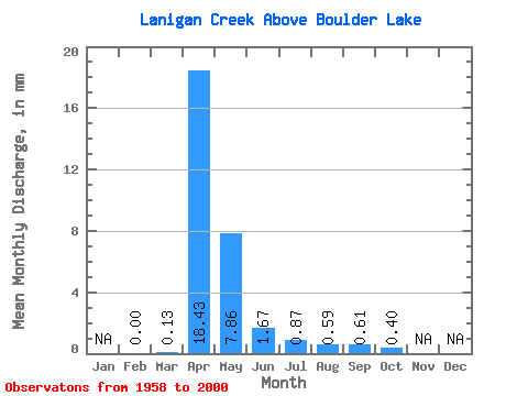
| Statistic | Jan | Feb | Mar | Apr | May | Jun | Jul | Aug | Sep | Oct | Nov | Dec | Annual |
|---|---|---|---|---|---|---|---|---|---|---|---|---|---|
| Mean | 0.00 | 0.01 | 1.82 | 0.78 | 0.17 | 0.09 | 0.06 | 0.06 | 0.04 | ||||
| Standard Deviation | 0.04 | 2.60 | 1.42 | 0.34 | 0.18 | 0.14 | 0.18 | 0.13 | |||||
| Min | 0.00 | 0.00 | 0.00 | 0.00 | 0.00 | 0.00 | 0.00 | 0.00 | 0.00 | ||||
| Max | 0.00 | 0.28 | 11.20 | 5.86 | 1.64 | 0.81 | 0.68 | 0.81 | 0.70 | ||||
| Coefficient of Variation | 3.57 | 1.43 | 1.83 | 2.06 | 2.05 | 2.47 | 2.98 | 3.29 |
 Return to R-Arctic Net Home Page