|
|
|||||||||||||||||
| Point ID: 538 | Downloads | Plots | Site Data | Code: 05FA022 |
|
|
|||||||||||||||||
| Download | |
|---|---|
| Site Descriptor Information | Site Time Series Data |
| Link to all available data | |
| View: | Time Series | All |
| Units: | m3/s |
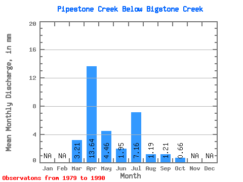
| Statistic | Jan | Feb | Mar | Apr | May | Jun | Jul | Aug | Sep | Oct | Nov | Dec | Annual |
|---|---|---|---|---|---|---|---|---|---|---|---|---|---|
| Mean | 2.66 | 11.27 | 3.69 | 1.61 | 5.92 | 0.99 | 1.00 | 0.55 | |||||
| Standard Deviation | 3.17 | 9.16 | 4.24 | 1.56 | 8.93 | 1.21 | 2.51 | 0.98 | |||||
| Min | 0.00 | 0.48 | 0.17 | 0.08 | 0.10 | 0.02 | 0.05 | 0.05 | |||||
| Max | 8.77 | 29.48 | 15.38 | 5.11 | 24.39 | 3.26 | 8.54 | 3.44 | |||||
| Coefficient of Variation | 1.20 | 0.81 | 1.15 | 0.96 | 1.51 | 1.23 | 2.50 | 1.79 |
 Return to R-Arctic Net Home Page