|
|
|||||||||||||||||
| Point ID: 5358 | Downloads | Plots | Site Data | Code: 05JE003 |
|
|
|||||||||||||||||
| Download | |
|---|---|
| Site Descriptor Information | Site Time Series Data |
| Link to all available data | |
| View: | Time Series | All |
| Units: | m3/s |
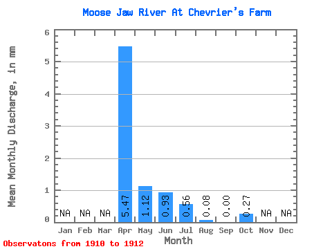
| Statistic | Jan | Feb | Mar | Apr | May | Jun | Jul | Aug | Sep | Oct | Nov | Dec | Annual |
|---|---|---|---|---|---|---|---|---|---|---|---|---|---|
| Mean | 3.07 | 0.63 | 0.52 | 0.32 | 0.04 | 0.00 | 0.15 | ||||||
| Standard Deviation | 0.04 | 0.18 | 0.33 | 0.06 | 0.00 | ||||||||
| Min | 3.07 | 0.60 | 0.39 | 0.08 | 0.00 | 0.00 | 0.15 | ||||||
| Max | 3.07 | 0.66 | 0.65 | 0.55 | 0.08 | 0.00 | 0.15 | ||||||
| Coefficient of Variation | 0.06 | 0.35 | 1.05 | 1.31 | 1.41 |
 Return to R-Arctic Net Home Page