|
|
|||||||||||||||||
| Point ID: 5355 | Downloads | Plots | Site Data | Code: 05JD004 |
|
|
|||||||||||||||||
| Download | |
|---|---|
| Site Descriptor Information | Site Time Series Data |
| Link to all available data | |
| View: | Time Series | All |
| Units: | m3/s |
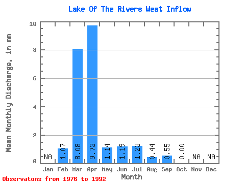
| Statistic | Jan | Feb | Mar | Apr | May | Jun | Jul | Aug | Sep | Oct | Nov | Dec | Annual |
|---|---|---|---|---|---|---|---|---|---|---|---|---|---|
| Mean | 1.01 | 7.67 | 9.27 | 1.08 | 1.15 | 1.19 | 0.40 | 0.51 | 0.00 | ||||
| Standard Deviation | 1.89 | 13.54 | 19.34 | 2.54 | 3.67 | 2.96 | 1.15 | 1.92 | 0.00 | ||||
| Min | 0.00 | 0.00 | 0.00 | 0.00 | 0.00 | 0.00 | 0.00 | 0.00 | 0.00 | ||||
| Max | 5.17 | 54.24 | 59.36 | 9.60 | 15.26 | 12.10 | 4.38 | 7.92 | 0.00 | ||||
| Coefficient of Variation | 1.87 | 1.77 | 2.09 | 2.34 | 3.20 | 2.49 | 2.90 | 3.77 |
 Return to R-Arctic Net Home Page