|
|
|||||||||||||||||
| Point ID: 5352 | Downloads | Plots | Site Data | Code: 05JC006 |
|
|
|||||||||||||||||
| Download | |
|---|---|
| Site Descriptor Information | Site Time Series Data |
| Link to all available data | |
| View: | Time Series | All |
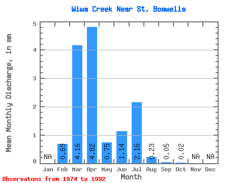
| Units: | m3/s |
| Statistic | Jan | Feb | Mar | Apr | May | Jun | Jul | Aug | Sep | Oct | Nov | Dec | Annual |
|---|---|---|---|---|---|---|---|---|---|---|---|---|---|
| Mean | 0.48 | 2.87 | 3.33 | 0.52 | 0.79 | 1.50 | 0.16 | 0.03 | 0.01 | ||||
| Standard Deviation | 0.68 | 3.82 | 4.97 | 0.94 | 2.60 | 4.25 | 0.47 | 0.09 | 0.06 | ||||
| Min | 0.00 | 0.00 | 0.00 | 0.00 | 0.00 | 0.00 | 0.00 | 0.00 | 0.00 | ||||
| Max | 1.46 | 14.14 | 17.97 | 3.17 | 11.09 | 17.86 | 1.92 | 0.35 | 0.24 | ||||
| Coefficient of Variation | 1.42 | 1.33 | 1.49 | 1.81 | 3.29 | 2.84 | 2.94 | 2.82 | 4.24 |
 Return to R-Arctic Net Home Page