|
|
|||||||||||||||||
| Point ID: 5346 | Downloads | Plots | Site Data | Code: 05JB004 |
|
|
|||||||||||||||||
| Download | |
|---|---|
| Site Descriptor Information | Site Time Series Data |
| Link to all available data | |
| View: | Time Series | All |
| Units: | m3/s |
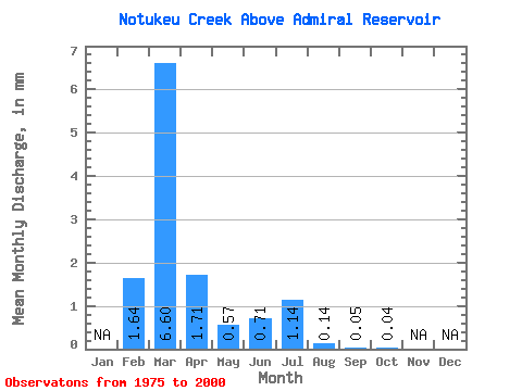
| Statistic | Jan | Feb | Mar | Apr | May | Jun | Jul | Aug | Sep | Oct | Nov | Dec | Annual |
|---|---|---|---|---|---|---|---|---|---|---|---|---|---|
| Mean | 1.20 | 4.76 | 1.23 | 0.41 | 0.51 | 0.82 | 0.10 | 0.04 | 0.03 | ||||
| Standard Deviation | 2.08 | 6.27 | 1.96 | 0.98 | 1.13 | 2.28 | 0.33 | 0.08 | 0.07 | ||||
| Min | 0.01 | 0.08 | 0.02 | 0.00 | 0.00 | 0.00 | 0.00 | 0.00 | 0.00 | ||||
| Max | 6.50 | 25.84 | 8.28 | 5.00 | 5.09 | 9.85 | 1.62 | 0.24 | 0.28 | ||||
| Coefficient of Variation | 1.74 | 1.31 | 1.59 | 2.39 | 2.20 | 2.76 | 3.34 | 2.17 | 2.26 |
 Return to R-Arctic Net Home Page