|
|
|||||||||||||||||
| Point ID: 5342 | Downloads | Plots | Site Data | Code: 05JA004 |
|
|
|||||||||||||||||
| Download | |
|---|---|
| Site Descriptor Information | Site Time Series Data |
| Link to all available data | |
| View: | Time Series | All |
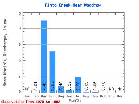
| Units: | m3/s |
| Statistic | Jan | Feb | Mar | Apr | May | Jun | Jul | Aug | Sep | Oct | Nov | Dec | Annual |
|---|---|---|---|---|---|---|---|---|---|---|---|---|---|
| Mean | 0.01 | 3.88 | 2.22 | 0.35 | 0.15 | 0.85 | 0.02 | 0.05 | 0.00 | ||||
| Standard Deviation | 0.01 | 6.60 | 3.28 | 0.79 | 0.38 | 3.37 | 0.07 | 0.20 | 0.01 | ||||
| Min | 0.00 | 0.00 | 0.00 | 0.00 | 0.00 | 0.00 | 0.00 | 0.00 | 0.00 | ||||
| Max | 0.03 | 23.63 | 11.49 | 3.19 | 1.41 | 14.32 | 0.32 | 0.86 | 0.05 | ||||
| Coefficient of Variation | 1.69 | 1.70 | 1.48 | 2.26 | 2.50 | 3.98 | 3.30 | 4.19 | 4.11 |
 Return to R-Arctic Net Home Page