|
|
|||||||||||||||||
| Point ID: 5339 | Downloads | Plots | Site Data | Code: 05JA001 |
|
|
|||||||||||||||||
| Download | |
|---|---|
| Site Descriptor Information | Site Time Series Data |
| Link to all available data | |
| View: | Time Series | All |
| Units: | m3/s |
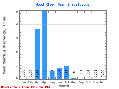
| Statistic | Jan | Feb | Mar | Apr | May | Jun | Jul | Aug | Sep | Oct | Nov | Dec | Annual |
|---|---|---|---|---|---|---|---|---|---|---|---|---|---|
| Mean | 0.00 | 0.00 | 2.56 | 3.46 | 0.43 | 0.58 | 0.69 | 0.07 | 0.01 | 0.03 | 0.01 | 0.00 | 5.17 |
| Standard Deviation | 0.00 | 0.00 | 4.18 | 2.51 | 0.35 | 1.21 | 1.67 | 0.16 | 0.01 | 0.04 | 0.01 | 0.00 | 3.13 |
| Min | 0.00 | 0.00 | 0.01 | 0.79 | 0.16 | 0.01 | 0.00 | 0.00 | 0.00 | 0.00 | 0.00 | 0.00 | 2.86 |
| Max | 0.00 | 0.00 | 13.99 | 8.50 | 1.28 | 3.77 | 4.82 | 0.46 | 0.04 | 0.10 | 0.03 | 0.00 | 10.41 |
| Coefficient of Variation | 1.63 | 0.72 | 0.83 | 2.07 | 2.41 | 2.17 | 2.05 | 1.43 | 1.68 | 2.45 | 0.61 |
 Return to R-Arctic Net Home Page