|
|
|||||||||||||||||
| Point ID: 5337 | Downloads | Plots | Site Data | Code: 05HH002 |
|
|
|||||||||||||||||
| Download | |
|---|---|
| Site Descriptor Information | Site Time Series Data |
| Link to all available data | |
| View: | Time Series | All |
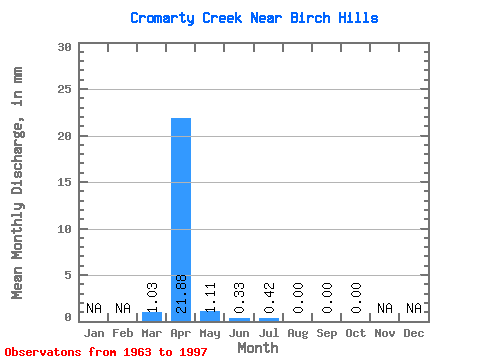
| Units: | m3/s |
| Statistic | Jan | Feb | Mar | Apr | May | Jun | Jul | Aug | Sep | Oct | Nov | Dec | Annual |
|---|---|---|---|---|---|---|---|---|---|---|---|---|---|
| Mean | 1.02 | 21.38 | 1.10 | 0.31 | 0.40 | 0.00 | 0.00 | 0.00 | |||||
| Standard Deviation | 2.39 | 24.67 | 2.00 | 0.66 | 1.60 | 0.00 | 0.00 | 0.00 | |||||
| Min | 0.00 | 0.00 | 0.00 | 0.00 | 0.00 | 0.00 | 0.00 | 0.00 | |||||
| Max | 9.38 | 103.41 | 8.22 | 2.89 | 7.66 | 0.00 | 0.00 | 0.00 | |||||
| Coefficient of Variation | 2.35 | 1.15 | 1.82 | 2.13 | 4.01 |
 Return to R-Arctic Net Home Page