|
|
|||||||||||||||||
| Point ID: 5313 | Downloads | Plots | Site Data | Code: 05HF012 |
|
|
|||||||||||||||||
| Download | |
|---|---|
| Site Descriptor Information | Site Time Series Data |
| Link to all available data | |
| View: | Time Series | All |
| Units: | m3/s |
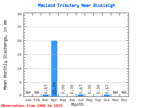
| Statistic | Jan | Feb | Mar | Apr | May | Jun | Jul | Aug | Sep | Oct | Nov | Dec | Annual |
|---|---|---|---|---|---|---|---|---|---|---|---|---|---|
| Mean | 0.10 | 4.37 | 0.00 | 0.02 | 0.07 | 0.00 | 0.00 | 0.07 | |||||
| Standard Deviation | 0.12 | 4.95 | 0.00 | 0.06 | 0.18 | 0.00 | 0.00 | 0.18 | |||||
| Min | 0.00 | 0.00 | 0.00 | 0.00 | 0.00 | 0.00 | 0.00 | 0.00 | |||||
| Max | 0.29 | 10.85 | 0.00 | 0.14 | 0.44 | 0.00 | 0.00 | 0.44 | |||||
| Coefficient of Variation | 1.23 | 1.13 | 2.45 | 2.45 | 2.45 |
 Return to R-Arctic Net Home Page