|
|
|||||||||||||||||
| Point ID: 5307 | Downloads | Plots | Site Data | Code: 05HF001 |
|
|
|||||||||||||||||
| Download | |
|---|---|
| Site Descriptor Information | Site Time Series Data |
| Link to all available data | |
| View: | Time Series | All |
| Units: | m3/s |
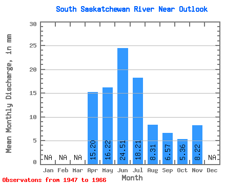
| Statistic | Jan | Feb | Mar | Apr | May | Jun | Jul | Aug | Sep | Oct | Nov | Dec | Annual |
|---|---|---|---|---|---|---|---|---|---|---|---|---|---|
| Mean | 9.76 | 10.41 | 15.73 | 11.69 | 5.33 | 4.22 | 3.44 | 5.28 | |||||
| Standard Deviation | 6.46 | 6.01 | 6.98 | 5.25 | 2.39 | 3.70 | 2.27 | ||||||
| Min | 3.81 | 3.29 | 7.57 | 3.56 | 1.04 | 0.61 | 0.61 | 5.28 | |||||
| Max | 23.06 | 30.52 | 34.12 | 23.04 | 10.30 | 14.54 | 9.51 | 5.28 | |||||
| Coefficient of Variation | 0.66 | 0.58 | 0.44 | 0.45 | 0.45 | 0.88 | 0.66 |
 Return to R-Arctic Net Home Page