|
|
|||||||||||||||||
| Point ID: 5302 | Downloads | Plots | Site Data | Code: 05HD037 |
|
|
|||||||||||||||||
| Download | |
|---|---|
| Site Descriptor Information | Site Time Series Data |
| Link to all available data | |
| View: | Time Series | All |
| Units: | m3/s |
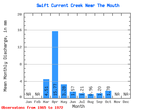
| Statistic | Jan | Feb | Mar | Apr | May | Jun | Jul | Aug | Sep | Oct | Nov | Dec | Annual |
|---|---|---|---|---|---|---|---|---|---|---|---|---|---|
| Mean | 3.05 | 10.64 | 2.22 | 1.06 | 0.82 | 0.65 | 0.81 | 1.20 | |||||
| Standard Deviation | 3.63 | 8.32 | 1.87 | 0.64 | 0.49 | 0.32 | 0.41 | 0.41 | |||||
| Min | 0.34 | 1.19 | 0.85 | 0.47 | 0.32 | 0.26 | 0.30 | 0.64 | |||||
| Max | 10.89 | 20.62 | 6.56 | 2.29 | 1.55 | 1.06 | 1.35 | 1.80 | |||||
| Coefficient of Variation | 1.19 | 0.78 | 0.84 | 0.60 | 0.60 | 0.50 | 0.51 | 0.34 |
 Return to R-Arctic Net Home Page