|
|
|||||||||||||||||
| Point ID: 53 | Downloads | Plots | Site Data | Code: 05AB038 |
|
|
|||||||||||||||||
| Download | |
|---|---|
| Site Descriptor Information | Site Time Series Data |
| Link to all available data | |
| View: | Time Series | All |
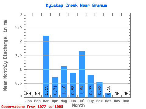
| Units: | m3/s |
| Statistic | Jan | Feb | Mar | Apr | May | Jun | Jul | Aug | Sep | Oct | Nov | Dec | Annual |
|---|---|---|---|---|---|---|---|---|---|---|---|---|---|
| Mean | 2.06 | 0.67 | 1.04 | 0.83 | 1.54 | 0.75 | 0.50 | 0.15 | |||||
| Standard Deviation | 6.38 | 1.16 | 1.96 | 1.08 | 4.42 | 2.79 | 1.22 | 0.60 | |||||
| Min | 0.00 | 0.00 | 0.00 | 0.00 | 0.00 | 0.00 | 0.00 | 0.00 | |||||
| Max | 25.80 | 3.53 | 6.72 | 2.92 | 18.37 | 11.55 | 4.68 | 2.48 | |||||
| Coefficient of Variation | 3.09 | 1.73 | 1.89 | 1.31 | 2.86 | 3.74 | 2.43 | 3.91 |
 Return to R-Arctic Net Home Page