|
|
|||||||||||||||||
| Point ID: 5278 | Downloads | Plots | Site Data | Code: 05HA076 |
|
|
|||||||||||||||||
| Download | |
|---|---|
| Site Descriptor Information | Site Time Series Data |
| Link to all available data | |
| View: | Time Series | All |
| Units: | m3/s |
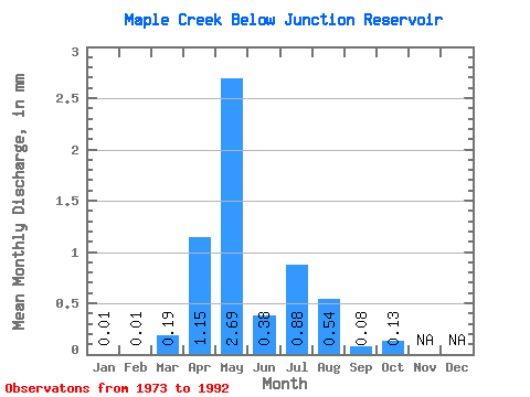
| Statistic | Jan | Feb | Mar | Apr | May | Jun | Jul | Aug | Sep | Oct | Nov | Dec | Annual |
|---|---|---|---|---|---|---|---|---|---|---|---|---|---|
| Mean | 0.01 | 0.01 | 0.14 | 0.85 | 2.00 | 0.28 | 0.65 | 0.41 | 0.06 | 0.09 | |||
| Standard Deviation | 0.02 | 0.39 | 0.78 | 1.22 | 0.82 | 0.94 | 1.03 | 0.12 | 0.14 | ||||
| Min | 0.01 | 0.00 | 0.00 | 0.00 | 0.00 | 0.00 | 0.00 | 0.00 | 0.00 | 0.00 | |||
| Max | 0.01 | 0.06 | 1.72 | 2.42 | 4.86 | 2.84 | 2.61 | 3.78 | 0.37 | 0.47 | |||
| Coefficient of Variation | 1.55 | 2.84 | 0.91 | 0.61 | 2.92 | 1.44 | 2.55 | 2.04 | 1.46 |
 Return to R-Arctic Net Home Page