|
|
|||||||||||||||||
| Point ID: 5272 | Downloads | Plots | Site Data | Code: 05HA069 |
|
|
|||||||||||||||||
| Download | |
|---|---|
| Site Descriptor Information | Site Time Series Data |
| Link to all available data | |
| View: | Time Series | All |
| Units: | m3/s |
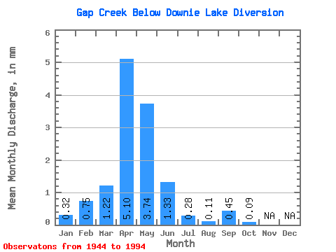
| Statistic | Jan | Feb | Mar | Apr | May | Jun | Jul | Aug | Sep | Oct | Nov | Dec | Annual |
|---|---|---|---|---|---|---|---|---|---|---|---|---|---|
| Mean | 0.29 | 0.69 | 1.13 | 4.71 | 3.45 | 1.22 | 0.26 | 0.10 | 0.41 | 0.08 | |||
| Standard Deviation | 0.15 | 1.08 | 2.81 | 14.15 | 8.11 | 2.95 | 0.76 | 0.55 | 1.82 | 0.32 | |||
| Min | 0.18 | 0.00 | 0.00 | 0.00 | 0.00 | 0.00 | 0.00 | 0.00 | 0.00 | 0.00 | |||
| Max | 0.40 | 2.58 | 16.64 | 77.10 | 45.92 | 18.42 | 4.67 | 3.88 | 11.80 | 1.61 | |||
| Coefficient of Variation | 0.53 | 1.56 | 2.49 | 3.00 | 2.35 | 2.42 | 2.92 | 5.62 | 4.40 | 3.89 |
 Return to R-Arctic Net Home Page