|
|
|||||||||||||||||
| Point ID: 5227 | Downloads | Plots | Site Data | Code: 05HA001 |
|
|
|||||||||||||||||
| Download | |
|---|---|
| Site Descriptor Information | Site Time Series Data |
| Link to all available data | |
| View: | Time Series | All |
| Units: | m3/s |
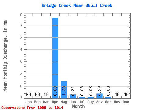
| Statistic | Jan | Feb | Mar | Apr | May | Jun | Jul | Aug | Sep | Oct | Nov | Dec | Annual |
|---|---|---|---|---|---|---|---|---|---|---|---|---|---|
| Mean | 6.45 | 1.31 | 0.31 | 0.06 | 0.05 | 0.40 | 0.08 | ||||||
| Standard Deviation | 4.59 | 1.58 | 0.64 | 0.14 | 0.11 | 0.75 | 0.14 | ||||||
| Min | 1.76 | 0.32 | 0.00 | 0.00 | 0.00 | 0.00 | 0.00 | ||||||
| Max | 10.93 | 4.11 | 1.45 | 0.32 | 0.24 | 1.53 | 0.24 | ||||||
| Coefficient of Variation | 0.71 | 1.21 | 2.10 | 2.24 | 2.24 | 1.88 | 1.73 |
 Return to R-Arctic Net Home Page