|
|
|||||||||||||||||
| Point ID: 5226 | Downloads | Plots | Site Data | Code: 05GG010 |
|
|
|||||||||||||||||
| Download | |
|---|---|
| Site Descriptor Information | Site Time Series Data |
| Link to all available data | |
| View: | Time Series | All |
| Units: | m3/s |
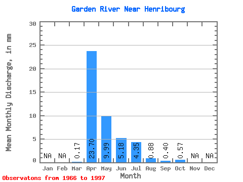
| Statistic | Jan | Feb | Mar | Apr | May | Jun | Jul | Aug | Sep | Oct | Nov | Dec | Annual |
|---|---|---|---|---|---|---|---|---|---|---|---|---|---|
| Mean | 0.07 | 9.76 | 4.11 | 2.13 | 1.79 | 0.36 | 0.16 | 0.23 | |||||
| Standard Deviation | 0.23 | 10.98 | 5.59 | 4.43 | 4.43 | 0.98 | 0.45 | 0.41 | |||||
| Min | 0.00 | 0.00 | 0.00 | 0.00 | 0.00 | 0.00 | 0.00 | 0.00 | |||||
| Max | 1.27 | 44.49 | 22.04 | 20.24 | 19.13 | 5.16 | 2.08 | 1.67 | |||||
| Coefficient of Variation | 3.36 | 1.12 | 1.36 | 2.08 | 2.47 | 2.69 | 2.78 | 1.77 |
 Return to R-Arctic Net Home Page