|
|
|||||||||||||||||
| Point ID: 521 | Downloads | Plots | Site Data | Code: 05EE009 |
|
|
|||||||||||||||||
| Download | |
|---|---|
| Site Descriptor Information | Site Time Series Data |
| Link to all available data | |
| View: | Time Series | All |
| Units: | m3/s |
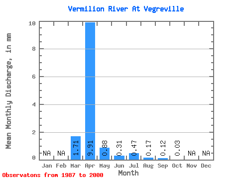
| Statistic | Jan | Feb | Mar | Apr | May | Jun | Jul | Aug | Sep | Oct | Nov | Dec | Annual |
|---|---|---|---|---|---|---|---|---|---|---|---|---|---|
| Mean | 0.68 | 3.91 | 0.35 | 0.12 | 0.19 | 0.07 | 0.05 | 0.01 | |||||
| Standard Deviation | 1.18 | 5.86 | 0.90 | 0.37 | 0.37 | 0.12 | 0.12 | 0.02 | |||||
| Min | 0.00 | 0.05 | 0.00 | 0.00 | 0.00 | 0.00 | 0.00 | 0.00 | |||||
| Max | 3.38 | 23.22 | 3.43 | 1.39 | 1.20 | 0.43 | 0.45 | 0.07 | |||||
| Coefficient of Variation | 1.74 | 1.50 | 2.61 | 3.04 | 2.00 | 1.79 | 2.46 | 1.73 |
 Return to R-Arctic Net Home Page