|
|
|||||||||||||||||
| Point ID: 5205 | Downloads | Plots | Site Data | Code: 05FF003 |
|
|
|||||||||||||||||
| Download | |
|---|---|
| Site Descriptor Information | Site Time Series Data |
| Link to all available data | |
| View: | Time Series | All |
| Units: | m3/s |
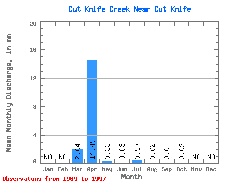
| Statistic | Jan | Feb | Mar | Apr | May | Jun | Jul | Aug | Sep | Oct | Nov | Dec | Annual |
|---|---|---|---|---|---|---|---|---|---|---|---|---|---|
| Mean | 1.69 | 12.01 | 0.27 | 0.03 | 0.47 | 0.01 | 0.01 | 0.01 | |||||
| Standard Deviation | 4.25 | 16.39 | 0.42 | 0.03 | 1.32 | 0.01 | 0.01 | 0.01 | |||||
| Min | 0.00 | 0.01 | 0.00 | 0.00 | 0.00 | 0.00 | 0.00 | 0.00 | |||||
| Max | 19.00 | 57.50 | 1.57 | 0.12 | 5.40 | 0.04 | 0.03 | 0.03 | |||||
| Coefficient of Variation | 2.52 | 1.36 | 1.56 | 0.98 | 2.80 | 0.85 | 0.91 | 0.83 |
 Return to R-Arctic Net Home Page