|
|
|||||||||||||||||
| Point ID: 5199 | Downloads | Plots | Site Data | Code: 05EG005 |
|
|
|||||||||||||||||
| Download | |
|---|---|
| Site Descriptor Information | Site Time Series Data |
| Link to all available data | |
| View: | Time Series | All |
| Units: | m3/s |
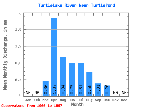
| Statistic | Jan | Feb | Mar | Apr | May | Jun | Jul | Aug | Sep | Oct | Nov | Dec | Annual |
|---|---|---|---|---|---|---|---|---|---|---|---|---|---|
| Mean | 0.28 | 1.46 | 0.73 | 0.62 | 0.63 | 0.45 | 0.24 | 0.21 | |||||
| Standard Deviation | 0.46 | 1.22 | 0.72 | 0.85 | 0.85 | 0.72 | 0.35 | 0.19 | |||||
| Min | 0.00 | 0.09 | 0.08 | 0.04 | 0.00 | 0.00 | 0.00 | 0.01 | |||||
| Max | 2.45 | 5.99 | 2.99 | 3.19 | 3.78 | 2.62 | 1.38 | 0.89 | |||||
| Coefficient of Variation | 1.63 | 0.84 | 0.98 | 1.38 | 1.36 | 1.59 | 1.45 | 0.91 |
 Return to R-Arctic Net Home Page