|
|
|||||||||||||||||
| Point ID: 5186 | Downloads | Plots | Site Data | Code: 04NA001 |
|
|
|||||||||||||||||
| Download | |
|---|---|
| Site Descriptor Information | Site Time Series Data |
| Link to all available data | |
| View: | Time Series | All |
| Units: | m3/s |
| Statistic | Jan | Feb | Mar | Apr | May | Jun | Jul | Aug | Sep | Oct | Nov | Dec | Annual |
|---|---|---|---|---|---|---|---|---|---|---|---|---|---|
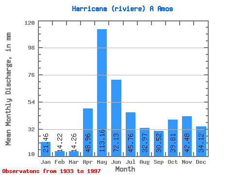
| Mean | 21.45 | 14.34 | 14.25 | 48.95 | 113.14 | 72.13 | 45.75 | 32.96 | 30.52 | 39.80 | 42.48 | 34.11 | 507.41 |
| Standard Deviation | 5.82 | 3.40 | 4.43 | 24.20 | 26.46 | 22.76 | 15.72 | 13.82 | 15.60 | 16.82 | 16.47 | 12.71 | 88.98 |
| Min | 9.68 | 7.56 | 7.11 | 9.93 | 58.58 | 38.67 | 20.09 | 8.15 | 10.07 | 15.43 | 12.47 | 12.59 | 326.54 |
| Max | 42.13 | 27.32 | 31.07 | 115.51 | 202.31 | 169.04 | 104.06 | 74.95 | 82.41 | 85.87 | 85.23 | 85.14 | 747.34 |
| Coefficient of Variation | 0.27 | 0.24 | 0.31 | 0.49 | 0.23 | 0.32 | 0.34 | 0.42 | 0.51 | 0.42 | 0.39 | 0.37 | 0.17 |
 Return to R-Arctic Net Home Page