|
|
|||||||||||||||||
| Point ID: 518 | Downloads | Plots | Site Data | Code: 05EE005 |
|
|
|||||||||||||||||
| Download | |
|---|---|
| Site Descriptor Information | Site Time Series Data |
| Link to all available data | |
| View: | Time Series | All |
| Units: | m3/s |
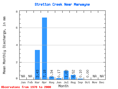
| Statistic | Jan | Feb | Mar | Apr | May | Jun | Jul | Aug | Sep | Oct | Nov | Dec | Annual |
|---|---|---|---|---|---|---|---|---|---|---|---|---|---|
| Mean | 3.25 | 6.82 | 0.33 | 0.15 | 0.96 | 0.49 | 0.09 | 0.01 | |||||
| Standard Deviation | 5.07 | 6.37 | 0.41 | 0.25 | 2.58 | 1.41 | 0.38 | 0.02 | |||||
| Min | 0.00 | 0.13 | 0.00 | 0.00 | 0.00 | 0.00 | 0.00 | 0.00 | |||||
| Max | 16.08 | 21.53 | 1.50 | 0.85 | 11.91 | 6.20 | 1.83 | 0.07 | |||||
| Coefficient of Variation | 1.56 | 0.93 | 1.27 | 1.64 | 2.67 | 2.89 | 4.48 | 2.82 |
 Return to R-Arctic Net Home Page