|
|
|||||||||||||||||
| Point ID: 5176 | Downloads | Plots | Site Data | Code: 03LD004 |
|
|
|||||||||||||||||
| Download | |
|---|---|
| Site Descriptor Information | Site Time Series Data |
| Link to all available data | |
| View: | Time Series | All |
| Units: | m3/s |
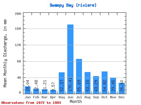
| Statistic | Jan | Feb | Mar | Apr | May | Jun | Jul | Aug | Sep | Oct | Nov | Dec | Annual |
|---|---|---|---|---|---|---|---|---|---|---|---|---|---|
| Mean | 18.04 | 12.59 | 11.21 | 9.57 | 52.36 | 170.41 | 85.88 | 53.14 | 43.29 | 54.81 | 39.45 | 26.59 | 579.50 |
| Standard Deviation | 3.31 | 2.40 | 2.16 | 1.87 | 43.98 | 50.87 | 31.36 | 20.45 | 16.83 | 23.84 | 9.45 | 4.81 | 84.48 |
| Min | 13.35 | 8.41 | 7.36 | 6.26 | 9.32 | 112.73 | 41.70 | 23.95 | 18.19 | 23.18 | 26.70 | 20.41 | 378.12 |
| Max | 28.21 | 18.67 | 15.79 | 14.21 | 155.20 | 284.28 | 176.35 | 104.86 | 90.24 | 110.22 | 58.53 | 41.41 | 737.31 |
| Coefficient of Variation | 0.18 | 0.19 | 0.19 | 0.20 | 0.84 | 0.30 | 0.36 | 0.39 | 0.39 | 0.43 | 0.24 | 0.18 | 0.15 |
 Return to R-Arctic Net Home Page