|
|
|||||||||||||||||
| Point ID: 5165 | Downloads | Plots | Site Data | Other Close Sites | Code: 03HB004 |
|
|
|||||||||||||||||
| Download | |
|---|---|
| Site Descriptor Information | Site Time Series Data |
| Link to all available data | |
| View: | Time Series | All |
| Units: | m3/s |
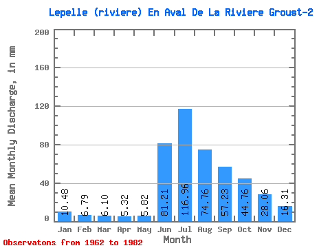
| Statistic | Jan | Feb | Mar | Apr | May | Jun | Jul | Aug | Sep | Oct | Nov | Dec | Annual |
|---|---|---|---|---|---|---|---|---|---|---|---|---|---|
| Mean | 10.48 | 6.85 | 6.10 | 5.32 | 5.81 | 81.21 | 116.94 | 74.74 | 57.23 | 44.76 | 28.06 | 16.30 | 452.43 |
| Standard Deviation | 2.91 | 2.01 | 1.94 | 1.76 | 2.26 | 37.78 | 34.89 | 22.56 | 18.08 | 13.39 | 10.16 | 5.01 | 117.54 |
| Min | 6.77 | 4.42 | 3.49 | 2.85 | 2.70 | 25.00 | 70.63 | 48.31 | 36.59 | 24.71 | 18.30 | 10.16 | 324.26 |
| Max | 17.17 | 12.68 | 11.81 | 10.49 | 12.68 | 152.22 | 174.33 | 141.51 | 108.25 | 73.25 | 53.87 | 25.84 | 780.23 |
| Coefficient of Variation | 0.28 | 0.29 | 0.32 | 0.33 | 0.39 | 0.47 | 0.30 | 0.30 | 0.32 | 0.30 | 0.36 | 0.31 | 0.26 |
| Other Close Sites | ||||||
|---|---|---|---|---|---|---|
| PointID | Latitude | Longitude | Drainage Area | Source | Name | |
| 5166 | "LEPELLE (RIVIERE) EN AVAL DE LA RIVIERE GROUST-1" | 60.19 | -976308 | Hydat | ||
 Return to R-Arctic Net Home Page