|
|
|||||||||||||||||
| Point ID: 5161 | Downloads | Plots | Site Data | Code: 03HA009 |
|
|
|||||||||||||||||
| Download | |
|---|---|
| Site Descriptor Information | Site Time Series Data |
| Link to all available data | |
| View: | Time Series | All |
| Units: | m3/s |
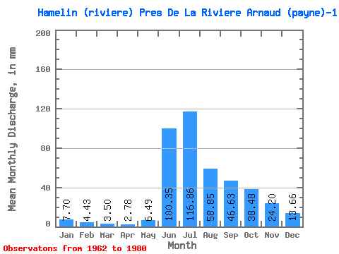
| Statistic | Jan | Feb | Mar | Apr | May | Jun | Jul | Aug | Sep | Oct | Nov | Dec | Annual |
|---|---|---|---|---|---|---|---|---|---|---|---|---|---|
| Mean | 7.70 | 4.46 | 3.50 | 2.78 | 6.48 | 100.35 | 116.85 | 58.85 | 46.63 | 38.48 | 24.20 | 13.65 | 414.77 |
| Standard Deviation | 3.36 | 2.23 | 1.99 | 1.76 | 6.32 | 45.28 | 25.88 | 13.43 | 11.96 | 8.55 | 5.03 | 4.05 | 60.79 |
| Min | 1.24 | 0.43 | 0.31 | 0.23 | 0.64 | 29.13 | 81.90 | 37.31 | 28.75 | 22.68 | 17.43 | 7.21 | 296.18 |
| Max | 13.20 | 9.42 | 8.90 | 8.18 | 22.30 | 165.46 | 174.85 | 82.55 | 78.64 | 55.38 | 33.22 | 20.48 | 526.05 |
| Coefficient of Variation | 0.44 | 0.50 | 0.57 | 0.63 | 0.97 | 0.45 | 0.22 | 0.23 | 0.26 | 0.22 | 0.21 | 0.30 | 0.15 |
 Return to R-Arctic Net Home Page