|
|
|||||||||||||||||
| Point ID: 5136 | Downloads | Plots | Site Data | Code: 03EC001 |
|
|
|||||||||||||||||
| Download | |
|---|---|
| Site Descriptor Information | Site Time Series Data |
| Link to all available data | |
| View: | Time Series | All |
| Units: | m3/s |
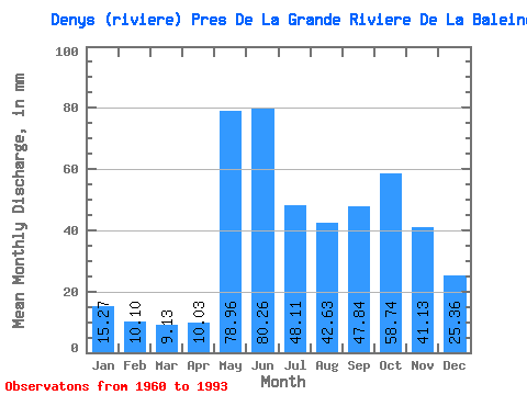
| Statistic | Jan | Feb | Mar | Apr | May | Jun | Jul | Aug | Sep | Oct | Nov | Dec | Annual |
|---|---|---|---|---|---|---|---|---|---|---|---|---|---|
| Mean | 15.26 | 10.19 | 9.12 | 10.03 | 78.95 | 80.26 | 48.10 | 42.63 | 47.84 | 58.73 | 41.13 | 25.36 | 467.30 |
| Standard Deviation | 2.53 | 1.60 | 1.70 | 6.45 | 28.23 | 26.69 | 17.09 | 17.78 | 17.34 | 18.22 | 10.35 | 5.76 | 64.24 |
| Min | 10.06 | 6.54 | 6.03 | 5.90 | 22.30 | 40.22 | 22.24 | 13.45 | 12.24 | 26.20 | 21.14 | 15.52 | 335.41 |
| Max | 21.95 | 13.35 | 13.04 | 40.60 | 135.62 | 146.29 | 104.02 | 87.93 | 81.77 | 96.55 | 69.53 | 39.88 | 573.07 |
| Coefficient of Variation | 0.17 | 0.16 | 0.19 | 0.64 | 0.36 | 0.33 | 0.35 | 0.42 | 0.36 | 0.31 | 0.25 | 0.23 | 0.14 |
 Return to R-Arctic Net Home Page