|
|
|||||||||||||||||
| Point ID: 5133 | Downloads | Plots | Site Data | Code: 03EA001 |
|
|
|||||||||||||||||
| Download | |
|---|---|
| Site Descriptor Information | Site Time Series Data |
| Link to all available data | |
| View: | Time Series | All |
| Units: | m3/s |
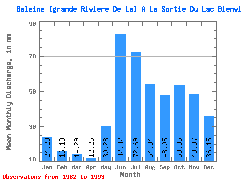
| Statistic | Jan | Feb | Mar | Apr | May | Jun | Jul | Aug | Sep | Oct | Nov | Dec | Annual |
|---|---|---|---|---|---|---|---|---|---|---|---|---|---|
| Mean | 24.28 | 16.33 | 14.29 | 12.25 | 30.28 | 82.83 | 72.68 | 54.33 | 48.05 | 53.84 | 48.87 | 36.15 | 504.92 |
| Standard Deviation | 3.86 | 2.67 | 2.49 | 2.23 | 15.14 | 22.84 | 20.82 | 17.44 | 15.72 | 11.31 | 11.27 | 6.99 | 71.05 |
| Min | 17.47 | 11.62 | 10.01 | 7.84 | 10.29 | 43.32 | 44.00 | 26.91 | 20.74 | 27.80 | 29.50 | 22.57 | 330.63 |
| Max | 32.39 | 22.43 | 20.53 | 18.64 | 76.51 | 144.41 | 132.62 | 106.86 | 86.40 | 73.84 | 75.54 | 51.27 | 656.13 |
| Coefficient of Variation | 0.16 | 0.16 | 0.17 | 0.18 | 0.50 | 0.28 | 0.29 | 0.32 | 0.33 | 0.21 | 0.23 | 0.19 | 0.14 |
 Return to R-Arctic Net Home Page