|
|
|||||||||||||||||
| Point ID: 512 | Downloads | Plots | Site Data | Code: 05ED002 |
|
|
|||||||||||||||||
| Download | |
|---|---|
| Site Descriptor Information | Site Time Series Data |
| Link to all available data | |
| View: | Time Series | All |
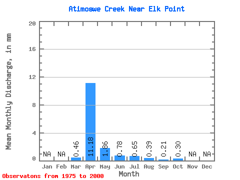
| Units: | m3/s |
| Statistic | Jan | Feb | Mar | Apr | May | Jun | Jul | Aug | Sep | Oct | Nov | Dec | Annual |
|---|---|---|---|---|---|---|---|---|---|---|---|---|---|
| Mean | 0.31 | 7.67 | 1.28 | 0.53 | 0.45 | 0.26 | 0.15 | 0.20 | |||||
| Standard Deviation | 0.58 | 7.72 | 1.61 | 1.02 | 0.85 | 0.42 | 0.19 | 0.22 | |||||
| Min | 0.00 | 0.06 | 0.01 | 0.01 | 0.00 | 0.00 | 0.00 | 0.01 | |||||
| Max | 1.89 | 28.41 | 6.61 | 4.48 | 4.04 | 1.70 | 0.66 | 0.91 | |||||
| Coefficient of Variation | 1.85 | 1.01 | 1.26 | 1.92 | 1.90 | 1.58 | 1.31 | 1.10 |
 Return to R-Arctic Net Home Page