|
|
|||||||||||||||||
| Point ID: 5107 | Downloads | Plots | Site Data | Code: 03CC002 |
|
|
|||||||||||||||||
| Download | |
|---|---|
| Site Descriptor Information | Site Time Series Data |
| Link to all available data | |
| View: | Time Series | All |
| Units: | m3/s |
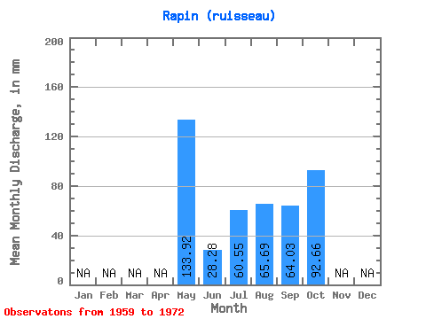
| Statistic | Jan | Feb | Mar | Apr | May | Jun | Jul | Aug | Sep | Oct | Nov | Dec | Annual |
|---|---|---|---|---|---|---|---|---|---|---|---|---|---|
| Mean | 133.90 | 28.29 | 60.55 | 65.69 | 64.03 | 92.63 | |||||||
| Standard Deviation | 69.77 | 43.47 | 39.42 | 29.66 | 39.01 | ||||||||
| Min | 84.57 | 28.29 | 14.78 | 23.62 | 19.49 | 65.78 | |||||||
| Max | 183.23 | 28.29 | 112.76 | 121.84 | 107.02 | 149.72 | |||||||
| Coefficient of Variation | 0.52 | 0.72 | 0.60 | 0.46 | 0.42 |
 Return to R-Arctic Net Home Page