|
|
|||||||||||||||||
| Point ID: 5103 | Downloads | Plots | Site Data | Code: 03CB002 |
|
|
|||||||||||||||||
| Download | |
|---|---|
| Site Descriptor Information | Site Time Series Data |
| Link to all available data | |
| View: | Time Series | All |
| Units: | m3/s |
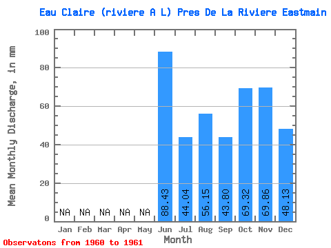
| Statistic | Jan | Feb | Mar | Apr | May | Jun | Jul | Aug | Sep | Oct | Nov | Dec | Annual |
|---|---|---|---|---|---|---|---|---|---|---|---|---|---|
| Mean | 88.43 | 44.04 | 56.14 | 43.80 | 69.31 | 69.86 | 48.12 | ||||||
| Standard Deviation | 7.80 | ||||||||||||
| Min | 88.43 | 38.52 | 56.14 | 43.80 | 69.31 | 69.86 | 48.12 | ||||||
| Max | 88.43 | 49.55 | 56.14 | 43.80 | 69.31 | 69.86 | 48.12 | ||||||
| Coefficient of Variation | 0.18 |
 Return to R-Arctic Net Home Page