|
|
|||||||||||||||||
| Point ID: 5095 | Downloads | Plots | Site Data | Code: 03BC001 |
|
|
|||||||||||||||||
| Download | |
|---|---|
| Site Descriptor Information | Site Time Series Data |
| Link to all available data | |
| View: | Time Series | All |
| Units: | m3/s |
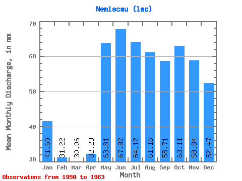
| Statistic | Jan | Feb | Mar | Apr | May | Jun | Jul | Aug | Sep | Oct | Nov | Dec | Annual |
|---|---|---|---|---|---|---|---|---|---|---|---|---|---|
| Mean | 41.60 | 31.49 | 30.06 | 32.23 | 63.80 | 67.81 | 64.11 | 61.16 | 58.71 | 63.10 | 58.84 | 52.46 | 645.20 |
| Standard Deviation | 6.91 | 5.65 | 5.29 | 10.00 | 10.73 | 12.38 | 15.16 | 16.02 | 15.06 | 15.32 | 10.59 | 7.86 | 93.01 |
| Min | 29.27 | 21.84 | 21.80 | 22.18 | 43.94 | 46.64 | 44.98 | 40.92 | 36.82 | 44.26 | 46.96 | 41.51 | 506.13 |
| Max | 50.35 | 40.21 | 38.63 | 56.72 | 83.81 | 93.16 | 94.94 | 89.70 | 81.12 | 87.08 | 80.48 | 62.40 | 744.70 |
| Coefficient of Variation | 0.17 | 0.18 | 0.18 | 0.31 | 0.17 | 0.18 | 0.24 | 0.26 | 0.26 | 0.24 | 0.18 | 0.15 | 0.14 |
 Return to R-Arctic Net Home Page