|
|
|||||||||||||||||
| Point ID: 5093 | Downloads | Plots | Site Data | Code: 03BB002 |
|
|
|||||||||||||||||
| Download | |
|---|---|
| Site Descriptor Information | Site Time Series Data |
| Link to all available data | |
| View: | Time Series | All |
| Units: | m3/s |
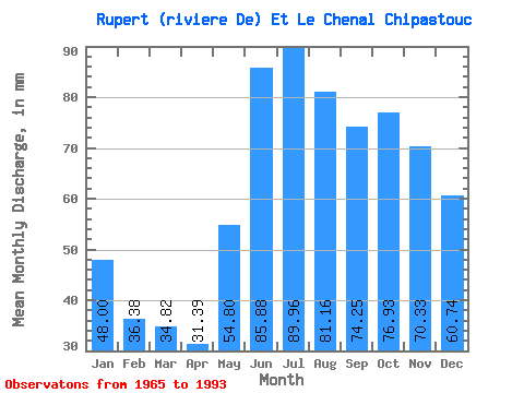
| Statistic | Jan | Feb | Mar | Apr | May | Jun | Jul | Aug | Sep | Oct | Nov | Dec | Annual |
|---|---|---|---|---|---|---|---|---|---|---|---|---|---|
| Mean | 47.99 | 36.69 | 34.81 | 31.39 | 54.80 | 85.88 | 89.95 | 81.14 | 74.25 | 76.92 | 70.33 | 60.73 | 735.11 |
| Standard Deviation | 8.07 | 6.52 | 6.07 | 5.17 | 10.99 | 16.65 | 17.34 | 14.98 | 13.29 | 12.33 | 10.72 | 9.31 | 87.15 |
| Min | 38.91 | 26.83 | 23.97 | 20.48 | 37.14 | 53.84 | 51.34 | 50.90 | 44.11 | 49.12 | 54.85 | 49.56 | 579.47 |
| Max | 68.36 | 50.69 | 46.31 | 39.09 | 78.71 | 116.86 | 119.55 | 108.75 | 98.81 | 104.75 | 95.66 | 85.22 | 954.79 |
| Coefficient of Variation | 0.17 | 0.18 | 0.17 | 0.17 | 0.20 | 0.19 | 0.19 | 0.18 | 0.18 | 0.16 | 0.15 | 0.15 | 0.12 |
 Return to R-Arctic Net Home Page