|
|
|||||||||||||||||
| Point ID: 5082 | Downloads | Plots | Site Data | Code: 03AC001 |
|
|
|||||||||||||||||
| Download | |
|---|---|
| Site Descriptor Information | Site Time Series Data |
| Link to all available data | |
| View: | Time Series | All |
| Units: | m3/s |
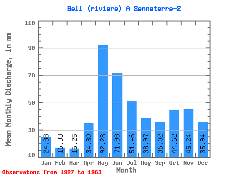
| Statistic | Jan | Feb | Mar | Apr | May | Jun | Jul | Aug | Sep | Oct | Nov | Dec | Annual |
|---|---|---|---|---|---|---|---|---|---|---|---|---|---|
| Mean | 24.88 | 17.08 | 16.25 | 34.80 | 92.26 | 71.98 | 51.45 | 38.97 | 36.02 | 44.61 | 45.24 | 35.93 | 507.80 |
| Standard Deviation | 6.31 | 3.97 | 3.86 | 17.57 | 32.27 | 28.38 | 19.04 | 14.23 | 15.02 | 23.76 | 20.03 | 10.56 | 111.32 |
| Min | 11.74 | 9.46 | 8.98 | 13.80 | 49.70 | 40.10 | 26.11 | 17.32 | 13.80 | 15.19 | 15.99 | 14.92 | 335.38 |
| Max | 38.64 | 23.91 | 27.58 | 89.75 | 207.84 | 170.22 | 100.19 | 78.74 | 77.63 | 139.90 | 97.62 | 62.49 | 861.88 |
| Coefficient of Variation | 0.25 | 0.23 | 0.24 | 0.51 | 0.35 | 0.39 | 0.37 | 0.36 | 0.42 | 0.53 | 0.44 | 0.29 | 0.22 |
 Return to R-Arctic Net Home Page