|
|
|||||||||||||||||
| Point ID: 507 | Downloads | Plots | Site Data | Code: 05EC004 |
|
|
|||||||||||||||||
| Download | |
|---|---|
| Site Descriptor Information | Site Time Series Data |
| Link to all available data | |
| View: | Time Series | All |
| Units: | m3/s |
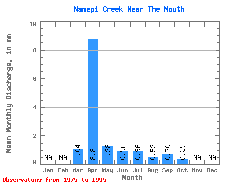
| Statistic | Jan | Feb | Mar | Apr | May | Jun | Jul | Aug | Sep | Oct | Nov | Dec | Annual |
|---|---|---|---|---|---|---|---|---|---|---|---|---|---|
| Mean | 0.85 | 7.17 | 1.04 | 0.78 | 0.78 | 0.42 | 0.57 | 0.32 | |||||
| Standard Deviation | 2.00 | 8.89 | 2.64 | 1.75 | 1.52 | 0.45 | 1.35 | 0.77 | |||||
| Min | 0.00 | 0.16 | 0.01 | 0.01 | 0.00 | 0.00 | 0.00 | 0.00 | |||||
| Max | 8.00 | 32.94 | 12.09 | 7.81 | 6.88 | 1.60 | 6.08 | 3.18 | |||||
| Coefficient of Variation | 2.36 | 1.24 | 2.53 | 2.24 | 1.93 | 1.05 | 2.37 | 2.43 |
 Return to R-Arctic Net Home Page