|
|
|||||||||||||||||
| Point ID: 5 | Downloads | Plots | Site Data | Code: 05AA005 |
|
|
|||||||||||||||||
| Download | |
|---|---|
| Site Descriptor Information | Site Time Series Data |
| Link to all available data | |
| View: | Time Series | All |
| Units: | m3/s |
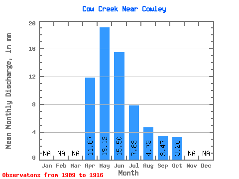
| Statistic | Jan | Feb | Mar | Apr | May | Jun | Jul | Aug | Sep | Oct | Nov | Dec | Annual |
|---|---|---|---|---|---|---|---|---|---|---|---|---|---|
| Mean | 11.87 | 19.11 | 15.51 | 7.81 | 4.72 | 3.46 | 3.27 | ||||||
| Standard Deviation | 3.63 | 7.19 | 10.76 | 7.04 | 3.53 | 2.79 | 1.51 | ||||||
| Min | 8.05 | 10.96 | 3.35 | 0.91 | 0.33 | 0.60 | 0.95 | ||||||
| Max | 15.28 | 29.03 | 33.15 | 19.15 | 11.48 | 9.47 | 5.94 | ||||||
| Coefficient of Variation | 0.31 | 0.38 | 0.69 | 0.90 | 0.75 | 0.81 | 0.46 |
 Return to R-Arctic Net Home Page