|
|
|||||||||||||||||
| Point ID: 490 | Downloads | Plots | Site Data | Code: 05EA002 |
|
|
|||||||||||||||||
| Download | |
|---|---|
| Site Descriptor Information | Site Time Series Data |
| Link to all available data | |
| View: | Time Series | All |
| Units: | m3/s |
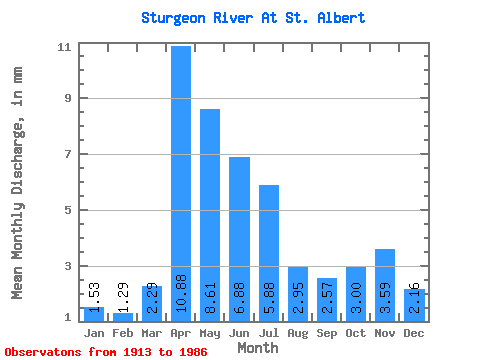
| Statistic | Jan | Feb | Mar | Apr | May | Jun | Jul | Aug | Sep | Oct | Nov | Dec | Annual |
|---|---|---|---|---|---|---|---|---|---|---|---|---|---|
| Mean | 1.22 | 1.04 | 1.83 | 8.71 | 6.89 | 5.51 | 4.70 | 2.36 | 2.06 | 2.40 | 2.88 | 1.73 | 75.34 |
| Standard Deviation | 0.77 | 0.67 | 1.83 | 5.95 | 6.27 | 6.75 | 5.85 | 2.28 | 1.98 | 2.00 | 0.06 | 0.29 | |
| Min | 0.68 | 0.57 | 0.00 | 0.66 | 1.09 | 0.70 | 0.08 | 0.00 | 0.00 | 0.00 | 2.84 | 1.53 | 75.34 |
| Max | 1.77 | 1.51 | 5.77 | 19.66 | 25.77 | 26.51 | 21.93 | 9.21 | 8.02 | 6.86 | 2.92 | 1.93 | 75.34 |
| Coefficient of Variation | 0.63 | 0.64 | 1.00 | 0.68 | 0.91 | 1.23 | 1.24 | 0.97 | 0.96 | 0.83 | 0.02 | 0.17 |
 Return to R-Arctic Net Home Page