|
|
|||||||||||||||||
| Point ID: 488 | Downloads | Plots | Site Data | Code: 05DF007 |
|
|
|||||||||||||||||
| Download | |
|---|---|
| Site Descriptor Information | Site Time Series Data |
| Link to all available data | |
| View: | Time Series | All |
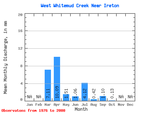
| Units: | m3/s |
| Statistic | Jan | Feb | Mar | Apr | May | Jun | Jul | Aug | Sep | Oct | Nov | Dec | Annual |
|---|---|---|---|---|---|---|---|---|---|---|---|---|---|
| Mean | 7.09 | 10.07 | 1.53 | 1.06 | 4.13 | 0.41 | 1.10 | 0.12 | |||||
| Standard Deviation | 8.41 | 11.88 | 2.08 | 1.60 | 7.24 | 1.17 | 3.40 | 0.38 | |||||
| Min | 0.00 | 0.00 | 0.00 | 0.00 | 0.00 | 0.00 | 0.00 | 0.00 | |||||
| Max | 31.78 | 37.40 | 6.98 | 4.72 | 22.79 | 5.25 | 16.07 | 1.72 | |||||
| Coefficient of Variation | 1.19 | 1.18 | 1.36 | 1.51 | 1.75 | 2.87 | 3.09 | 3.23 |
 Return to R-Arctic Net Home Page